


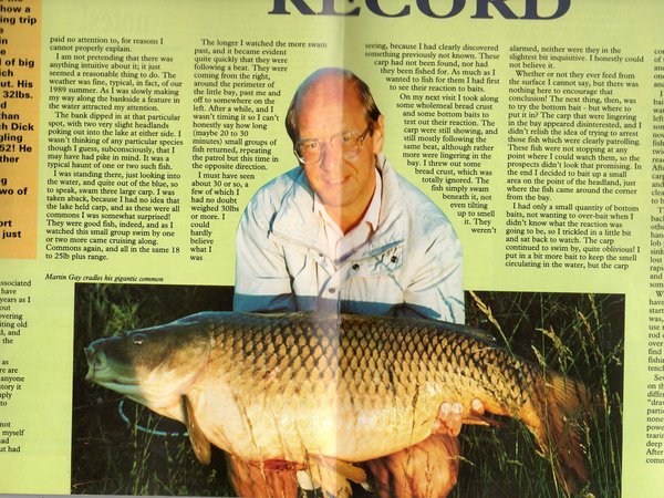
Martin went on to say that his first visit was one evening when he caught carp of 32lb. 18lb. and 21lb. He returned the following morning to capture the big carp which he reported as 48lb. He went on to tell us that it was a while before he could get back but that he returned to catch seven carp. The following morning he returned and caught nine carp. Again it was some time later before he could return, but early one Saturday morning he caught seven carp, went home and returned later to catch another four carp later the same morning. He writes that he saw carp up until August, then they disappeared. This means that he was fishing through July and August, when he was not in Canada but had returned to England.
“As far as I can remember, there was a notice board in the background which may have given something away, but the general scenery was not that of an English lake”
The above statement made by Robin Monday in a letter to Tim Paisley, published in Carpworld, number 8, dated March/April 1990, following the publication of Martins carp captures in Coarse Angler in November 1989, was, I feel, the catalyst for the Canada carp rumours that have subsequently been taken by many to be fact.
We have never been told what Robin saw that led him to state that the general scenery was not that of an English lake.
Why is it that his version of what he saw in the photo is completely at odds with the 12 others who saw it?
Fast forward now to Martins reports of his catches in 1990 in his articles entitled ‘Nine and a half weeks’ published between December 1990 and March 1991.
He tells us that he fished on 19, 20 and 21 June, and then went on holiday to Scotland. He then fished again on 11th, 12th, 13th, 14th, 15th, 20th, 29th July, and 1st, 12th, 13th, 14th August. It is hardly believable that he could have been in Canada in June, returned home, went on holiday to Scotland, then returned to Canada for July and August. In addition to which he attended a meeting of the Moor Hall & Belhus A.S. on Tuesday the 14th August which proves he was in fact in England not Canada. His visits to Canada were not annual holidays so he would not have visited in 1989 and again the following Summer in 1990.
Now I know at this point many of you will be thinking ‘we’ve heard all this before’ and ‘same old, same old’ but please bear with me on this as I feel it is important to ‘map out’ a route to reach a conclusion. From a beginning to an end, hopefully!
So, if Martin made his carp catches in Canada, as has been stated by certain persons, whereabouts in Canada were they caught from?
According to Paul Selman in June 2013 “It is fact that when Martin caught those fish he was on holiday in British Colombia, Canada. It is my understanding that the part of the picture blocked out did indeed show a Canadian mountain landscape. These conclusions were also accepted as fact by the Carp Society leadership of the time and his claims were not accepted by us”
He was then challenged by the hugely experienced Geoff Maynard who said “Interesting Paul. However BC is not really a known big carp area to my knowledge”.
Paul responded to this with “Geoff, there is fantastic big carp fishing in BC, one of my friends is a guide there”. He went on to say “one million percent… ask Jim Gibbinson he will tell you. Well I did ask Jim. All he would say is ‘Ask Robin Monday he knows all about it’
Well it was British Columbia for Paul Selman (for 25 years) right up until very recently when, in a complete turnaround to what was previously held to be fact, Paul now tells us all:
“The fish were caught from a warm water outlet from Lennox Power Station on Lake Ontario, Canada, bits of the power station are missed off the picture so as not to reveal the location” and he also tells us “… Ontario is a noted carp area, British Colombia isn’t”
So after 25 years of ‘one million per cent BC’ we are now told it is ‘one million per cent’ Lennox Power Station instead! This means, of course, that the Carp Society got it completely and utterly wrong in the first place. In any case where did Paul Selman get this information from? He never saw any photos. Surely he didn’t make it up did he ?
Robin Monday never mentioned a power station anywhere. Rather strange don’t you think?
So what was it that caused this sudden and dramatic change of location I wonder ?
Now excuse my suspicious mind, but it appears that it was only after Cliff Hatton revealed that the Committee members of Moor Hall & Belhus A.S. had seen the photo (and others) before Robin Monday (and unanimously agreed there were no mountains, only scrubland) that the story regarding the Lennox Power Station suddenly appeared.
Following on from this we were shown this photo which Paul confidently stated was the very swim from which Martin caught his carp. He even explained to us all how Martin would have parked his car in the road behind and returned to it for a wash and brush-up before being photographed with his catch. Where does Paul Selman conjure-up all this incredible detail from?
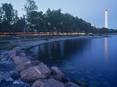
And it’s not Lennox Power Station at all !! It’s Kingston General Hospital and the smoke stack, 21 miles further up Lake Ontario. Paul Selman seems to have given zero thought to his choice of illustration…and the consequences.
So, we are told that Martin took a walk (Martin explained how he manoeuvred around his lake) around Lake Ontario and visited the warm water outlet where he saw the carp and subsequently made his catches.
So not only does Paul Selman tell us the location and name of the lake but also the actual swim! But is it not strange that no one else has honed in on this hot spot? Why do carp anglers based in Toronto make a five hour drive past this wonderful hot spot for carp to visit the St. Lawrence area?
Well, when I contacted the Corporate Relations Department of Ontario Power regarding the chimneys I also asked them about the warm water outlet and they told me:
“The area where the outflow comes out is accessible by boat”. Yes, that’s right “accessible by boat”. They also sent me a further two photos which I will come to later on in this article.
I then found out that a Boat License is required on Lake Ontario and there are no places to launch a boat anywhere near the warm water outflow anyway…no mention of boats and licences from Martin’s nephew – only that his uncle came home “…white and visibly shaking” and no subsequent report of him “…coming home elated” later in his fortnight’s stay.
Think about that! You can’t have one without the other. If, during a fortnight’s stay under the same roof with his relatives, Martin came home “…white and visibly shaking” at seeing some big carp (according to what JamesN says he was told by Martin’s nephew) then Martin MUST ALSO have been seen returning elated at catching such magnificent specimens. This also makes a mockery of Paul Selman’s oft-repeated non-truth that ‘Martin’s own family says he caught the fish from L.Ontario’. THEY HAVE SAID NO SUCH THING. We have heard NOTHING from them.
Now a lot of what has gone before has centred on the ‘edited photo’ of Martin.
In September I noticed a blog on Anglers Forum by a James Hart in which he referred to ‘Looking at the plants and also the substrate’ and I was interested to hear what he had to say, so I contacted him and this is what he told me:
“I don’t have any professional qualifications in this field just a strong interest and years of reading and watching the subject matter. First if you look at the larger stones they appear quite rounded, the only thing that can do that to a stone or a rock is constant contact with a large area of water and time. Second was the plants , all low growing so I would say the area the picture was taken in was very open/windy. The other time you see plants like that is when they are in fairly close contact to salty areas, I bet you could find something similar close to the coast around Kent, Essex and Sussex”
I also sent him the photo of Kingston General Hospital and the smoke stack to which he replied “that’s definitely not the same place the picture on the Angling Forum was taken”.
This stirred my interest even further and I thought that this line of enquiry could lead somewhere. I found out that Professor David Bridgland of Durham University had given a talk to the Essex Rock and Mineral Society whilst I was on holiday in October, so I contacted him when I returned home. He referred me to Dr. Peter Allen who he informed me had been his Phd Supervisor, and was the man to speak to describing him as ‘a font of all knowledge’ on the subject.
During my own research I had found out that Lake Ontario was carved out of soft, weak Silurian-age rocks by the Wisconsin ice sheet during the last ice age. Material that was pushed southward by the ice sheet left landforms such as drumlins, kames, and moraines. Kame terraces are composed of sands and gravels, but form along the sides of the glacier rather than at its snout. Because the deposits in a Kame Terrace have been transported by water, they become sorted, enabling them to be distinguished from lateral morain deposits which exhibit no sorting.
The following photo which I obtained from Ontario Power shows a Kame Terrace.
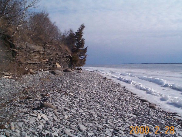
Ontario Power which operates Lennox Power Station tell me that this is a photo of the actual shoreline of Lake Ontario adjacent to the warm water outlet. Note the distinctive flat stones – completely unlike those in the photos of Martin Gay with his giant common carp. Also note that the shore is completely devoid of plant life.
As you can clearly see, it doesn’t bear any resemblance whatsoever to any of the photos of Martin and the big common carp.
Before contacting Dr Peter Allen I attended the November meeting of the Essex Rock and Mineral Society and took along with me the photos that have been shown in this article. Although I am not a member I was able to speak with a Committee man and show him the photos. His response was that the photo of Martin is definitely not the same place as the other photos.
As James Hart had not yet seen this photo I sent him a copy and asked for his comments as well. He advised me “It is not the same place at all”
I then contacted Dr Peter Allen and sent him the same photos. His reply appears later in this article.
As can be seen from the following aerial photo (also sent to me by Ontario Power) the Kame Shelves run for as far as the eye can see.
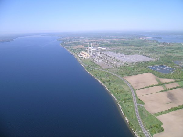
Martin’s highly detailed and lengthy accounts of his lake-caught commons bear no relation to this daunting landscape (showing the real Lennox power station)
The photos of the Kame Shelves and the aeriel photo were provided by Jennifer Gardiner, Corporate Relations & Communications, Ontario Power Generation.
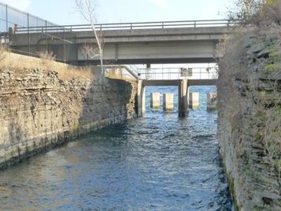
So for all of you who just love photos here is another one taken a few days ago of the Lennox Power Station Warm Water Outlet looking out towards Lake Ontario.
I can just picture Martin saying ‘Pass me the landing net, Yvonne, I’ve just hooked another one. No not that one, silly, the one with the extra, extra, long handle’.
I was sent these photos by Terry Brady, a Canadian, who is employed as the Enviromental Advisor at Lennox Power(Generating) Station.
I then E Mailed Terry with a few questions which are shown below. This is the actual unedited text with his answers shown in blue.
Hi Terry
That was really good of you to get those photos, thank you very much.
You mention that carp can be seen in the channel itself, but from the photo of the channel there doesn’t seem to be anywhere you could fish from, it all looks a bit dangerous somehow. It would be very dangerous now. Back in 1989, the fence didn’t extend all the way to the shoreline on the west side of the channel so it would have been possible to fish at the lake end of channel.
Does anyone fish for them now ? People still walk down there to go fishing, but our Operators will ask them to leave if they see them
How big are they ? Most fishermen range in size from 160 lbs to 245 lbs (sorry). The biggest carp I’ve seen is probably 30 lbs.
Would anglers have boat fished ? There are boat fisherman who try their luck for trout and walleye in the lake out from the channel, but no one enters the channel. I’ve actually boat fished (unsuccessfully) there myself but I wasn’t fishing for carp.
Would you have any idea at all about the signs or the type of fencing back in 1989 ? Here is a photo from 2002, it is the closest to 1989. You’ll see that there wasn’t much signage on the fencing.
Any extra information you provide me with might prove useful. I don’t think anything close to a 50 lb common has ever been caught in Ontario waters.
In my opinion, your friend was being honest. The people who doubt him probably don’t believe that man walked on the moon in ‘69 either.
So this is it probably what it looked like in 1989.

As you can see there is a fence and there is a sign on it. But none of this remotely resembles anything that we saw in the photos. No trees, no dead trees, no reeds, no rushes and no concrete posts.
Having made this contact it seemed sensible to ask a little bit about himself and pose a few more questions and this was his response.
“ I am Canadian. I work at the Lennox Generating Station as the Environmental Advisor and I’ve been at this plant since 1997. Prior to that I worked at the Darlington Nuclear Generating Station. I’m 58, and will be retiring in late January after 34 years with Ontario Hydro/Ontario Power Generation.
“I’ve spent most of my life in this part of Ontario. I was born and raised in Napanee, which is about 12 km miles north of the plant. I now live in Kingston, 20 km east of the station. I know this area very well and have fished in most of the waters around here. I used to be an avid walleye fisherman when I lived in Napanee because the Napanee river and Bay of Quinte were world class walleye waters. You didn’t need to have good angling skills to catch a lot of fish, so it was perfect for me. Other species that are popular in this area are pike, largemouth and smallmouth bass, catfish, lake trout, rainbow trout, salmon, and muskie. Oddly enough, carp are typically not fished in this area, even though there is an abundance of them. I’ve never fished for them but I have latched onto a couple by accident. Wow… they are amazing fighters so I’m surprised anglers don’t seek them more often. I’ve never personally known anyone, or known of anyone, who goes fishing for carp. I only fish a couple of times a year now in the Thousand Islands region of the St. Lawrence river, for bass and pike, but I plan on doing a LOT more once I’m retired.
You’re correct, boats do require a registration number. Also, anyone fishing must have a fishing licence. This applies to Ontario residents and visitors alike. There is a boat launch 6 km east of the plant. I’ve never seen anyone fishing for carp directly out from the outfall channel. They’re typically out farther in the lake trying to catch trout. I also saw a lot of anglers last February out on the ice in their portable ice huts. Apparently, one of the anglers was very successful in catching lake trout so he posted a video on social media, informing others of the location. I can understand why Martin Gay didn’t divulge the location where fish was caught. People would have been there in droves.”
In a further E Mail to me he said.
“…I don’t know my vegetation very well, but I do know a biologist who just recently did some work for us. He should be able to identify the plants in the photo. I’ll send them to him to see if he can help”.
Terry
I then sent Terry a copy of the first article that Martin wrote as I was sure that he had never seen it or heard of it before, he responded.
“Hi Eddie.
Those articles were very enjoyable. You’re right, it doesn’t appear to be Lake Ontario at all…. I’m not sure where the carp go in the winter as there is no vegetation at all along our shoreline. They may move over to Amherst Island or Prince Edward county.
You’re correct, our Operations staff conduct inspection rounds of the water discharge points every 4 hours. They would have requested anyone fishing at the outfall to leave the premises”
I received a response from Dale Kristensen (biologist with Queen’s University) regarding the identification of vegetation species in the photos.
According to Dale, “…the plants can be found in both Canada and Great Britain”.
So Dale Kristensen, a biologist with Queens University, having examined the photos had this to say.
“Hi Terry,
BW Photo:
Tough to say, but it may be Horseweed (Conyza canadensis) – a common introduced weed in rough soils across Britain, and found throughout our region as well.
Colour Photo:
I’m pretty sure the grasses on the right of this photo are of Poa pratensis (Kentucky bluegrass), a common introduced upland grass across the British Isles– found pretty much anywhere except in wet locations here as well.
Cheers,
Dale”
So much then for erstwhile botanist. Paul Selman’s decree: “He (Martin) should have blanked out the plant too, a species not native to the UK”
Remember the Kame Terraces and my reference to Dr. Peter Allen? Well if you haven’t heard of him, read on.
PETER ALLEN Selective publications list’
Articles in Journals
Allen, P. 2000 Global warming and its possible impact on Essex. Essex Naturalist, 17 (New Series), 6-15.
Allen, P. 2001 The retreat of the Late Pliocene and Lower Pleistocene Crag sea and the development of the Early Pleistocene Thames – a review. Essex Naturalist, 18 (New Series), 9-28.
Moorlock, B.S.P., Riding, J.B., Hamblin, R.J.O., Allen, P. and Rose, J. 2002 The Pleistocene College Farm Silty Clay at Great Blakenham, Suffolk, England – additional information on the course of the early River Thames. Netherlands Journal of Geosciences, 81, 9-17.
Schreve, D.C., Bridgland, D.R., Allen, P., Blackford, J.J., Gleed-Owen, C.P., Griffiths, H.I., Keen, D.H. and White, M.J. 2002 Sedimentology, palaeontology and archaeology of late Middle Pleistocene River Thames terrace deposits at Purfleet, Essex, UK. Quaternary Science Reviews, 21, 1423-1464.
Schreve, D.C., Harding, P., White, M.J., Bridgland, D.R., Allen, P., Clayton, F., Keen, D.H. and Penkman, K.E.H. 2006 A Levallois knapping site at West Thurrock, Lower Thames, U.K: Its Quaternary context, environment and age. Proceedings of the Prehistoric Society, 72, 21-52.
Wenban-Smith, Allen, P., Bates, M.R., Parfitt, S.A., Preece, R.C., Stewart, J.R., Turner, C. and Whittaker, J.E. 2006 The Clactonian Elephant Butchery Site at Southfleet Road, Ebbsfleet, U.K. Journal of Quaternary Science, 21, 471-483.
Bridgland, D.R., Harding, P., Allen, P. et al. 2013 An enhanced record of MIS 9 geoarchaeology: data from construction of the High Speed I (London-Channel Tunnel) rail-link and other recent investigations at Purfleet Essex. Proceedings of the Geologists’ Association, 124, 417-476.
Chapters/Articles in Books
Allen, P. 2004 The geology of Foxhall Road and the surrounding area. In: White, M. and Plunkett, S. (eds) Miss Layard Excavates: a Palaeolithic site at Foxhall Road, Ipswich, 1903-1905. Western Academic and Specialist press Limited, Liverpool. Pp. 55-75.
Allen, P.2012 Deducing glacier behaviour in Suffolk. In: Dixon, R. (ed.), A Celebration of Suffolk Geology. GeoSuffolk, Ipswich. Pp. 327-339.
Wenban-smith, F., Bates, M., Allen, P., Bates, R. and Hutchinson, J. 2013 Geology, stratigraphy and site phasing. In: Wenban-Smith (ed.) The Ebbsfleet Elephant: Excavations at Southfleet `Road, Swanscombe in Advance of High-Speed 1, 2003-4. Pp. 57-110.
Bridgland, D., Wenban-Smith, F., White, T.S. and Allen, P. 2013 Clast Lithology. In: Wenban-Smith (ed.) The Ebbsfleet Elephant: Excavations at Southfleet Road, Swanscombe in Advance of High-Speed 1, 2003-4. Pp. 139-147.
Bridgland, D.R. and Allen, P. 2014 Quaternary fluvial systems and river terraces. In: Catt, J.A. and Candy, I. (eds) The History of the Quaternary Research Association, London. Pp. 249-299.
Bridgland, D.R., Allen, P. and White, T.S. (eds) 2014 The Quaternary of the Lower Thames and Eastern Essex. Field Guide. Quaternary Research Association, London.
Bridgland, D.R. & Allen, P. Finches Quarry, 133-136.
Bridgland, D.R., Allen, P., et al. Wansunt Pit, Dartford Heath, 152-157.
Schreve, D.C., Allen, P. et al. Greenlands Quarry, Purfleet, 157-177
Schreve, D.C., Allen, P. et al. Lion Pit Tramway Cutting, W. Thurrock, 177-189.
Reports
Over 40 technical geological reports relating to archaeological sites, mostly in the Essex, Kent and Suffolk.
That’s quite a list isn’t it ?
I put it to him that the physical characteristics of the ‘Kame Shelves’ are completely different to the ‘pebbles’ etc. in the fishing photos. He replied:
“I agree. The Kame Shelves photo has flat rounded disc-shaped pebbles (length and breadth about equal, height very small – good for my boyhood delight of skimming pebbles on water) whereas the fish photo has angular/sub-angular equant pebbles (length, breadth and height nearer to being equal – useless for skimming”)
I just love the analogy, skimming pebbles, I think we can all identify with that.
I went on to ask him ‘from what you can see in those photos is it evident that it is not the shoreline of Lake Ontario ?
He replied “I can say that the beach pebbles on the fish photo are not the same as those on the Kames photo and that they are different places”.
This was confirmed by Professor David Bridgland.
So, four geologists who have stated independently that the geological makeup of the fishing photo is completely different to that of the shoreline at Lennox Power Station – not that we can’t see it for ourselves of course.
I will finish this article with a little nugget taken from the Angling Times dated Tuesday December 31, 1991. The article was titled ‘Record Prospects’ and asked some big fish experts of the time for their predictions for 1992.
This is what Chris Yates had to say.
“I’m fed up with some of the carp anglers of today, although some are very nice. But I would certainly like to see Martin Gay beat the carp record. His large common carp is an absolutely genuine British capture, and I hope he returns to the old private reservoir where it was caught to catch an even bigger one”
Eddie Benham